I'm back from the Motorcycle Sport Touring Association (MSTA) Sport Touring Association Rendezvous (STAR) event in Rapid City, SD traveling from June 4th to 16th 2014. The trip report is below ...
Immediately after STAR 2014 was announced, I knew I'd be making the trip. No internal debates, discussions with others or vacillation on my part! It has been more than 15 years since I last visited South Dakota. That visit was for Sturgis--the event, not the town. My focus during that three-day visit was on certain "activities" in town. This time, I was determined to maximize the fantastic riding to be had in this area.
While I'm naturally prone to engage in moto-trips that are limited in planning and big on make-it-up-as-you-go adventure creativity, this time, with many miles, limited time, and Central Coast member Les Katz traveling along with me, it seemed best to assemble A Plan. My usual approach to route planning involves (too?) many mapping tools, Internet hotel finder sites, and numerous file imports/exports between Google Maps, Garmin's multiple software products and my GPS. Given that I wanted to share the planning with my riding partner (an important ingredient to maintain long-term riding friends), doing all the planning in sharable Google Maps seemed wise. But, alas, many limitations were encountered.
To my great pleasure, I discovered a new service Furkot (www.furkot.com) that met my needs nicely. I won't bore you with all the details beyond listing a few key Furkot features: Google Mapping, passthru waypoints, overnight points, day planning, integrated hotel searches and auto-routing based on vehicle type (Furkot knows the difference between planning for cars and motorcycles!).
Here are the results:
My planned "to STAR" route: https://trips.furkot.com/ts/b4vJQP
And, return "from STAR" route: https://trips.furkot.com/ts/qhm42u
If you like what you see, give it a try (it's free!). Now, back to the actual trip.
My plan was to include in the route as many Motorcycle RoadsTM as possible on the way to STAR and shorten the trip home to be just "direct" enough to get back in the available four return days. Mission accomplished.
Day 1 Mariposa. This was our early get-away day. Les and I met at a favorite restaurant east of Paso Robles late in the afternoon. Our target destination was Mariposa. We wanted to put the central valley behind us and position ourselves for riding the Sierras the next day. Accomplished.
Day 2 Winnemucca. This day's ride was all about the Sierras. Hwy 49 and 88 combined for an enjoyable re-introduction to the mountains. On arrival in Carson City, NV, our focus for the remainder of the day became getting miles behind us as we covered the flat lands. We took full advantage of the high posted speed on Interstate 80 (our longest planned section of interstate road) to cover a total of 380 miles for the day.
Day 3 Stanley. Now we're into the exciting middle days of the trip. After an early morning run north into Oregon, we spent the majority of the day traveling through the Saw Tooth mountains of Idaho. Hwy 95 in Nevada and Oregon, while not particularly twisty, was pleasant riding through open country, occasional sweeping turns, continuous elevation climbs and some forest. As we traveled Oregon, snow capped peaks were often on our horizon.
Passing near Boise brought us heavy local traffic. Bumper-to-bumper stop-n-go traffic met us on Hwy 55 as we turned north. Those 8 miles were the slowest of the entire trip.
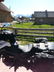
Hwy 55, Forest Road 17 and Hwy 21 combined to lead us into Stanley, our home for the night. What a fantastic place! This small town located in a mountain bowl provided us with a 360 degree view of snow covered peaks. And, the only "hotels" were three log cabin style resorts. Fortunately for us, the summer busy season was still one week away. No one was at our chosen "hotel"--the Stanley High Country Inn. The local owners were very hospitable. Any guest is better than no guests. We stayed in a deluxe room right off the main lodge gathering great room. Immediately outside our door was the huge central great room with a dozen tables, comfortable chairs, couches, vaulted ceilings, panoramic views, cozy fireplace and buffet service area. The town's 6,300 foot elevation meant a cool evening and likely even cooler morning.
Day 4 Ennis. As expected, the morning dawned cold. Temperatures in the high 30s helped us to wake up at 6 am. Now I understand why the staff made a point to explain the heater controls in our room the evening before. Maybe this was a good day for a slow, lazy start. After taking full advantage of hot breakfast in the main room, with many coffee refills, we mounted up near 9 am to head east through the now much warmer 50 degree air.
Hwy 75 chased the Salmon River until Hwy 93 took over. An entire morning of mountain views, river at our side, twisty road broken all broken only by the occasional ranch. Fantastic!
Some 160 miles later, we turned east, entered Montana by follow Hwy 43, then south on 278. This was mostly open country with sweeping turns and big views. Montana is indeed "Big Sky" country. A one-exit ride north on Interstate 15 delivered us to Hwy 41 then Hwy 287, again. Over one last set of mountains for the day then a long downhill into Ennis, which is located on the Madison River. Our hotel was a series of small cottages along the river.
Day 5 Lovell. Many of the visitors in Ennis were pointed to the same morning destination as were we--Yellowstone NP in Wyoming. A two-hour morning ride through the low mountains around Hebgen Lake and we were in gateway city of West Yellowstone for breakfast. We choose the northern most road through Yellowstone to exit the park back into Montana.
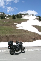
Continuing on Hwy 212 took us through the Bear Tooth Pass. Charles Kuralt called this "the most beautiful drive in America". I certainly have no basis to correct him. This route was breathtaking. At 10,947 feet, this high pass receives considerable snowfall so it only opens for a few months of the year. As expected, while the road was clear and dry, there was nothing but snow at the top. Numerous "adventurers" were skiing from the roadside down steep cliffs to be collected at a lower points and brought back up to do it again by their friends in cars. If you've not ridden here, plan a trip.
We finished off this mostly high mountain scenery day with Hwy 308, 72 and 310 in Montana, which brought us back into Wyoming to the city of Lovell. This was a hard working farm town with dust, dirt and mud everywhere. It didn't help that the main street of town was torn-up for construction. We checked out the two hotels in town and choose the marginally better of the two. Nice people here (as we later learned) but this town does not present itself well to travelers. A short walk from our combination hotel and Chinese/steak(?) restaurant was a local family style eatery a few blocks off the main street. While the menu was unimaginative fare, the service was friendly. The owner joined us tableside for some time to discuss the going's-on in the area. Definitely pleasant folks.
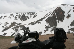
Day 6 Rapid City! We intended to finish off the trip with the highest pass through a last mountain range--the Bighorns. East out of Lovell, Hwy 14 Alt took us to high elevations over a very few miles. Temperatures dropped rapidly to near 30 degrees. In short order we were surrounded by snow overlapping the roadway. Winds picked up to become a continuous freezing blast out of the north. The roadway gathered increasing amounts of snow as we continued higher, which then became ice. At some point, I noticed that the road was now completely covered with ice from edge-to-edge. After a gentle stopping procedure, Les and I conferred from our mounts in the middle of the road. Thankfully we need not get off the road as no other vehicles were foolish enough to be up in the pass in these conditions! There was unanimous agreement to reverse course. We gently left Hwy 14 Alt behind and returned to the relative warmth of the lower country.
Our chosen alternative was the slightly lower pass through the Bighorns via Wyoming Hwy 16 to Buffalo, Wy. "Cloud Peak Skyway" greeted us with a clear road, cold 35 degree temperatures and light rain/snow/ice in the air. But, the road stayed mostly dry with just some thankfully liquid water in patches. After consuming so much time trying to get over the Bighorns, Interstate 90 was warmly welcomed.
We followed I90 all the way to Rapid City enduring occasional showers along the way.
On arrival at STAR, no matter which direction they traveled from, members were sharing their stories of cold and rain. The locals were just as puzzled telling us that such cool wet weather was very unusual for this time of year. In fact it should be uncomfortably hot. I'm good with cool and wet if the alternative is 90 and muggy, thank you.
Accommodations at STAR were very nice. The Holiday Inn's architecture was designed around a large central atrium. Eight stories of rooms and a 60 foot waterfall all faced to the center of the glass-roofed atrium. An open wall-less restaurant at the base made it easy to locate friends. Large rooms included a couch, coffee table, desk and multiple flat screens (one for each bed!).
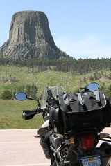
There were no shortage of destinations and moto-roads around Rapid City. In fact, so many I failed to get to all the locations planned. We did visit Keystone for a 2-hour steam powered train ride, see Mt Rushmore and Crazy Horse monuments, shop at Wall Drugs, tour a Minuteman Missile silo, and ride a loop through the Badlands National Park. The lunch ride was to the Ponderosa Cafe in Hulett, Wy, which was near Devil's Tower a granite monolith sticking up out of a very flat plain. Downtown Rapid City looked very inviting but, in spite of daily rides through it, I never set foot there.
California was represented by Les and myself along with ageless Don Clark. I want to be just like him when I grow up!
By the way, in case you've not heard, STAR 2015 was announced to be in Paso Robles, CA! Guess they heard about our annual spring ride and the great wine to be had. Er, my mistake. Springdale, Arkansas will be substituting for Paso. Too far? Can't make it? Well then join us in April 2015 in Paso!
Heading home is always a bit sad. Each mile, each hour, brings the fun closer to the end in what seems to be a much more direct way than any other part of the trip. But, although more direct and shorter, our return still had plenty of riding fun in it.
Return Day 1 Fort Collins. We used Hwys 79, 18, 85 and 20, along with farm road 270, to get us onto Interstate 25 in Wyoming. An afternoon ride down I25 to Fort Collins Colorado ended our day. After a sold out hotel hosting a Mormon Woman's Conference directed us to alternative accommodations, all worked out well as we ended up across the parking lot from a tasty Mexican restaurant.
Return Day 2 Price. Riding most of the morning through the Poudre Canyon on Hwy 14 in Colorado delivered one spectacular view after another. Switching to Hwy 40 lead us over Rabbit Ears Pass into Steamboat Springs. Nice town but full of traffic so this was very slow going.
Continuing on Hwy 40 across the high western plains of Colorado was nice but uninteresting riding save the strong winds.
Traffic picked up substantially in Utah on 40 then thinned out as we turned onto Hwy 191 heading south through the mountains to Price Utah.
The Best Western desk person in Price turned out to be the hotel owner visiting from Irvine California. He gave us the "special California friends" rate, assigned us the first room near the top of the stairs (saving us from substantial luggage toting), and encouraged us to park the bikes on the sidewalk under his awning. I'm feeling pretty good about Price!
Return Day 3 Tonopah. A short morning ride on Hwy 10 then we turned on Hwy 31. Wow! What a nice road and great discovery! This National Scenic Byway climbs continuously from south to north to over 9,000 feet. On this day, at this early morning hour, it was one cold ride! Perfectly clear deep blue sky helped to ensure no heat was held close to the ground overnight. Temperatures at the top were around 30 degrees. As it was morning, thankfully there was little wind. This road is now on my "must visit again" list.
The usual long boring ride across Hwy 50 lead us to Ely, Nevada for a brief refuel and snack stop. Then off on the long run on Hwy 6 from Ely to Tonopah.
After 170 miles of Nevada desert, we arrived in Tonopah where my Triumph's computer was dutifully warning me that I had zero miles of fuel range remaining. Filling it at the first available station on the edge of town educated me that I actually had 10 miles of fuel remaining. Good to know.
The Best Western in the center of town was our home for the night. Surprisingly, this hotel has dedicated motorcycle parking in front of the office and a very complete hot breakfast with omelets and sausage. Another on the "remember for future trips" list.
Next door was the Mizpah hotel where we had dinner. Another spot worth considering for next time. The Mizpah is restored to its original glory and boasts a number of historic visitors and events--including a haunting. The Lady in Red was a Tonopah call girl in the 1920s. She courted her companions at the Mizpah Hotel until one night when she was murdered in a crime of passion. Apparently she remains on the 5th floor to host current day visitors.
Return Day 4 home. Get-home-syndrome was setting in as we awoke. Now only one day's ride from home we were ready to be there. Our last bit of purpose-made road was just south of Tonopah--Hwy 266 and 165 cross the border into California with style via narrow and very tight roadway near the Black and White Mountains.
We worried there might be some "travel drama" as we saw the fires near Lake Isabella but, as we drew close, it was clear the fire was on the mountain overlooking the town and did not impact our travel on Hwy 178.
The remainder of the day was uneventful. I arrived back in my Paso Robles garage at 4 pm.
The entire trip track, shown below, can be seen at: https://www.buttonhome.org/pages/star2014.html.
And trip pictures are at: https://www.buttonhome.org/piwigo/index.php?/category/31.
Overall I'd rate this as one of the best STAR events I've attended. Not just for the "event" but considering the location, route coming and going, along with the range of possibilities at the event, it was a good one. I'd go again tomorrow. If you didn't make it you missed a good one!